Explore the East Asia Geography Map and Key Features
7/15/2026
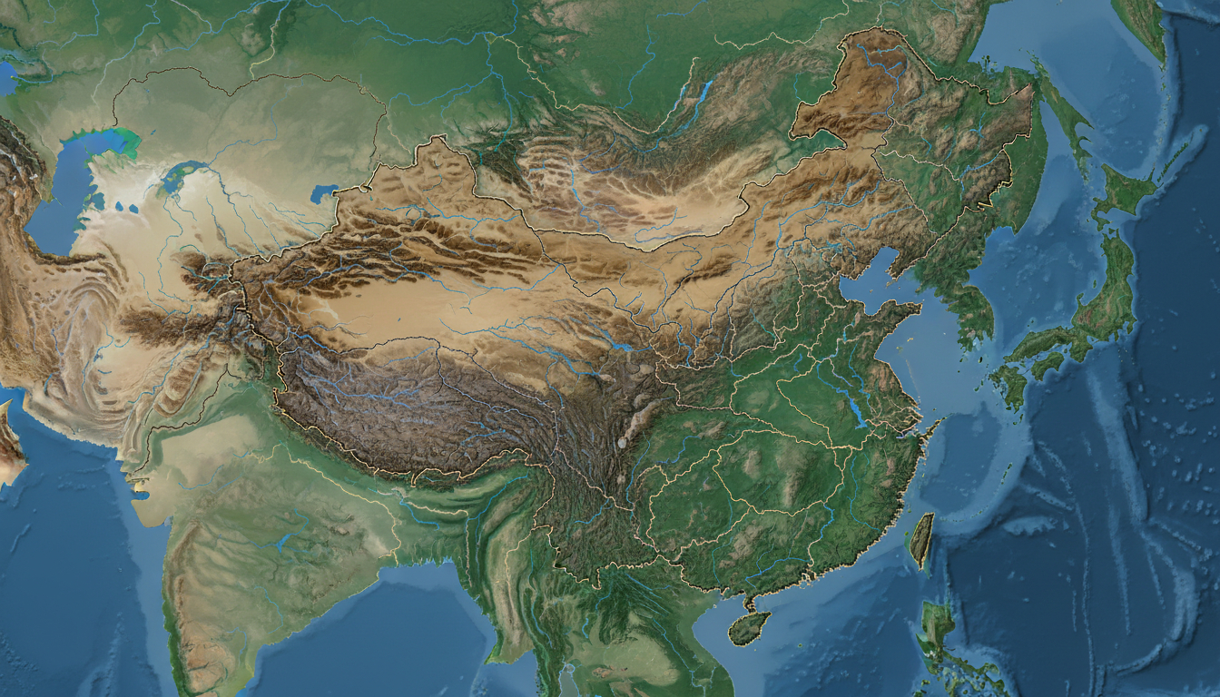
In short, what you'll discover in this article: Explore a comprehensive east asia geography map that reveals political borders, physical landscapes, climate zones, and population distribution. Learn how to use interactive layers for detailed insights into East Asia’s countries, major geographic features, and natural risks.
1. Introduction — What Is an East Asia Geography Map and Why It’s Useful
An east asia geography map is a detailed visual representation of the region’s countries, physical features, climate zones, and demographic patterns. Such maps are essential for understanding the spatial relationships between nations like China, Japan, Korea, Mongolia, and Taiwan.
They help travelers, students, and researchers grasp the complex geography of East Asia, from mountain ranges to river systems.
This map is particularly useful for planning trips, studying regional dynamics, or simply satisfying curiosity about how East Asia’s diverse landscapes and political boundaries interact. A clear map reduces confusion caused by cluttered or unclear visuals and supports better learning and decision-making.
2. Main Interactive Map of East Asia
The main interactive east asia geography map offers multiple layers to explore different aspects of the region’s geography. Users can toggle between political boundaries, physical features, climate zones, and demographic data for a comprehensive understanding.
2.1 Political Layer — Countries, Borders, and Capitals
This layer highlights the political boundaries separating East Asian countries such as China, Japan, North Korea, South Korea, Mongolia, Taiwan, Hong Kong, and Macau. Capitals like Beijing, Tokyo, Seoul, and Ulaanbaatar are clearly marked to provide orientation.
The political layer helps users visualize how countries are positioned relative to one another and understand territorial disputes or administrative divisions within the region.
2.2 Physical Layer — Mountains, Plains, Plateaus, and Major Rivers
The physical features layer showcases East Asia’s varied terrain:
- Mountain ranges including the Himalayas’ eastern edges and the Japanese Alps
- Extensive plains like the North China Plain
- Plateaus such as the Mongolian Plateau
- Major rivers including the Yangtze, Yellow River (Huang He), Amur River, and Mekong tributaries
These features shape climate patterns and human settlement across East Asia.
2.3 Climate Layer — Climate Zones and Precipitation
This layer displays the diverse climate zones across East Asia:
- Humid subtropical zones in southern China and Japan
- Continental climates in Mongolia and northern China
- Monsoon-influenced regions with seasonal rainfall variations
Understanding these zones helps explain agricultural practices and population distribution.
2.4 Demographic Layer — Population and Density by Region
Population density varies widely across East Asia. This layer highlights:
- Dense urban centers like Tokyo-Yokohama metropolitan area
- Sparsely populated regions such as Mongolia’s steppes
- Coastal population clusters in South Korea and eastern China
This demographic insight supports travel planning and economic analysis.
2.5 How to Use the Map (Zooming, Layers, Legend, Filters)
To maximize the map’s utility:
- Use zoom controls to focus on specific countries or cities.
- Toggle layers on/off to compare political borders with physical geography.
- Refer to the legend for color codes representing climate zones or population density.
- Apply filters to highlight features like mountain ranges or river basins.
This interactive approach makes exploring East Asia’s geography intuitive.
3. Country Profiles and Subregions
3.1 China — Key Geographic Facts and Detailed Map
China dominates East Asia geographically with vast mountains (Himalayas), plateaus (Tibetan Plateau), rivers (Yangtze), and diverse climates from arid northwest deserts to humid southeast coasts. Its political boundaries encompass multiple provinces with distinct landscapes.
3.2 Japan — Relief, Islands, and Unique Features
Japan consists of four main islands plus numerous smaller ones with mountainous terrain shaped by volcanic activity. The Japanese Alps run through Honshu island while coastal plains support dense populations in cities like Tokyo.
3.3 South Korea / North Korea — Geography and Sensitive Points
The Korean Peninsula features rugged mountains in the east with flatter western plains where most cities lie. Political division between North Korea and South Korea adds complexity to geographic understanding.
3.4 Mongolia, Taiwan, and Island Territories (Hong Kong, Macau)
Mongolia is largely plateau with desert steppes; Taiwan is mountainous with tropical forests; Hong Kong and Macau are small but densely populated urban territories on the coast.
4. Major Geographic Features
4.1 Mountain Ranges and Notable Peaks
East Asia’s significant mountain ranges include:
- Himalayas (Mount Everest nearby)
- Altai Mountains
- Japanese Alps
- Changbai Mountains on the China-North Korea border
These ranges influence weather patterns and biodiversity.
4.2 Major Rivers and Watersheds
Key rivers shaping East Asia:
- Yangtze River: longest in Asia flowing through central China
- Yellow River: cradle of Chinese civilization
- Amur River: border river between Russia and China
- Mekong tributaries affecting southern China’s climate
These waterways support agriculture and transportation.
4.3 Important Islands and Archipelagos
Besides Japan’s islands:
- Taiwan island with mountainous terrain
- South China Sea archipelagos including disputed islands
- Coastal islands near Hong Kong and Macau
Islands play strategic roles in geopolitics.
5. Natural Risks and Tectonics
5.1 Seismic Activity and Major Fault Lines
East Asia lies along tectonic boundaries causing frequent earthquakes especially in Japan, Taiwan, eastern China coastlines.
5.2 Volcanoes and Tsunami Risks
Volcanic activity is prominent in Japan’s ring of fire region; tsunamis pose threats to coastal areas around the Pacific Ocean rim.
6. Advanced Thematic Maps
6.1 Population Density & Urbanization (Megacities & Metropolitan Areas)
Maps reveal megacities like Tokyo (over 37 million people), Seoul metropolitan area, Shanghai cluster—all hubs of economic activity with high population density.
6.2 Languages, Ethnicities & Cultural Distribution
Ethnic groups such as Han Chinese dominate mainland China; Koreans populate both Koreas; Mongols in Mongolia; Japanese on their islands; indigenous minorities scattered throughout.
6.3 Economy & Infrastructure (Ports, Corridors & Logistics Hubs)
Major ports include Shanghai (world’s busiest), Busan in South Korea; infrastructure corridors connect industrial zones facilitating trade across East Asia.
7. History of Borders — Comparative Historical Maps
Historical maps illustrate shifting boundaries influenced by wars, treaties, colonialism—helping users understand current geopolitical tensions.
8. Data Formats & Integration
8.1 Downloads (SVG, KML, GeoJSON) & Integration Examples
Users can download maps in scalable vector graphic formats or GIS-compatible files for custom projects or presentations.
8.2 API & Dynamic Layers (e.g., Leaflet/Mapbox Live Additions)
Developers can integrate live map layers into websites or apps using APIs supporting dynamic data overlays for real-time updates.
9. Sources, Methodology & Data Updates
The data behind this east asia geography map comes from trusted geographic databases updated regularly to reflect changes in political borders or natural features (source) ensuring accuracy for users relying on it for travel or study.
10. Conclusion And Call To Action
This east asia geography map offers an invaluable tool for anyone seeking a clear visual understanding of East Asia’s complex geography—from political borders to natural landscapes. To deepen your exploration or plan your travels effectively, download the interactive map now or integrate it into your projects for ongoing updates.
For travelers planning trips within East Asia who need reliable connectivity alongside geographic insights, consider checking out eSIM data plans available for Singapore at singaporesim.com. Using an eSIM can keep you online seamlessly while exploring major cities shown on your map.
Additionally, if you want broader regional context beyond East Asia itself, explore our detailed map of Southeast Asia for neighboring countries’ geography.
For tourists visiting Singapore after exploring East Asia who want hassle-free mobile data access during their stay in this travel hub city—our guide on Singapore eSIM tourist plans offers practical advice on choosing the best plan.
By combining geographic knowledge with smart connectivity solutions like eSIMs recommended by MyBestSim's top-ranked providers such as Roamic (promo code MYBESTSIM), you ensure a smooth travel experience across East Asia’s diverse landscapes.
Explore more maps or start your journey today!
FAQ
What countries are included in the East Asia geography map?
The map covers China, Japan, North Korea, South Korea, Mongolia, Taiwan, Hong Kong, and Macau. It highlights their political borders, capitals, and key geographic features for a comprehensive regional overview.
How does the climate layer help understand East Asia?
The climate layer shows diverse zones like humid subtropical, continental, and monsoon-influenced areas. This helps explain regional agriculture, weather patterns, and population distribution across East Asia.
What major physical features are highlighted on the map?
Key physical features include mountain ranges such as the Himalayas and Japanese Alps, extensive plains like the North China Plain, plateaus including the Mongolian Plateau, and major rivers like the Yangtze and Yellow River.
How can users interact with the East Asia geography map?
Users can zoom in on specific areas, toggle layers for political, physical, climate, or demographic data, use legends to interpret colors, and apply filters to focus on features like mountains or rivers for detailed exploration.
What natural risks are shown on the East Asia geography map?
The map highlights seismic activity zones along tectonic boundaries causing earthquakes, volcanic regions especially in Japan, and tsunami risks along Pacific coastal areas, providing insight into natural hazards in East Asia.

Liam Chen
Liam is a travel and technology writer based in Southeast Asia who has tested eSIMs across the region. At Singapore eSIM he compares travel data plans on Singtel, StarHub and M1 and helps visitors stay online affordably from Changi to Sentosa.