Explore the Asia Geographical Map for Travel and Planning
7/22/2026
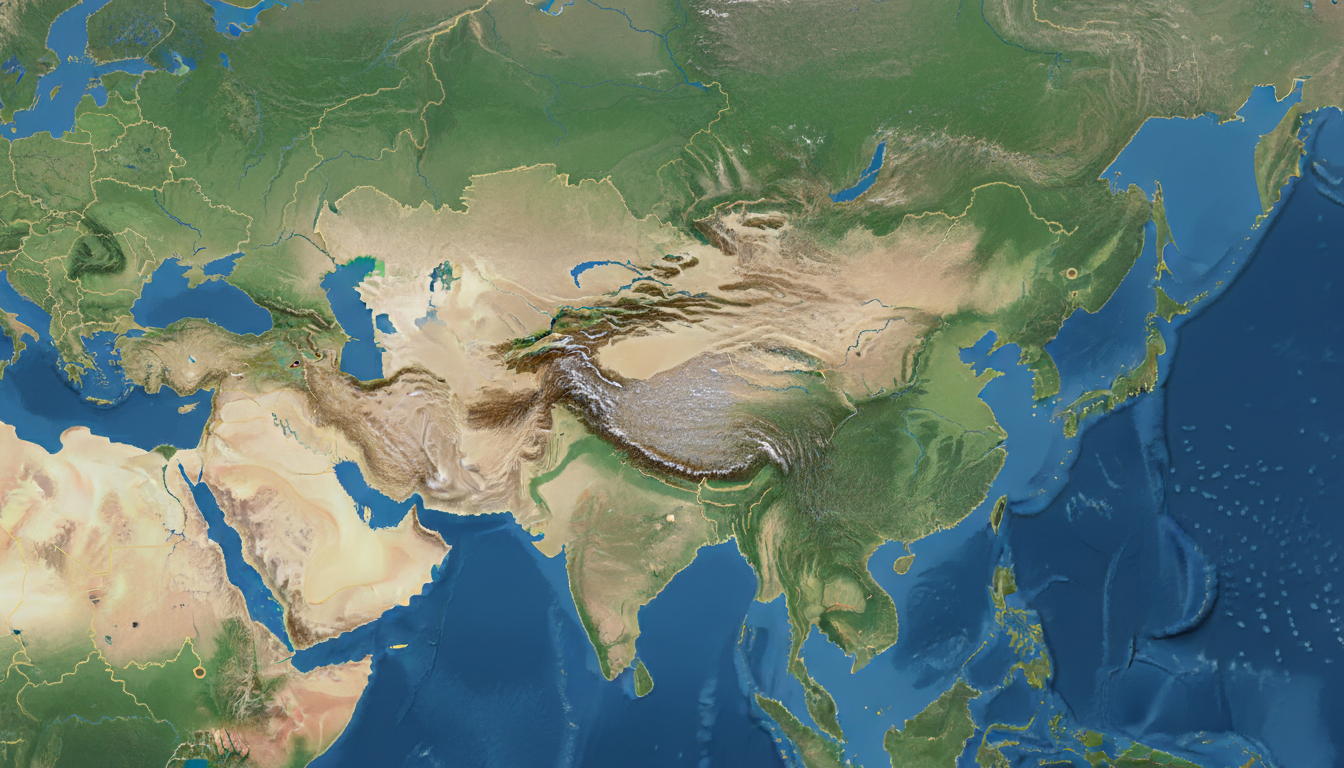
In short, what you'll discover in this article: A comprehensive overview of the asia geographical map, including physical features, political boundaries, and key regional details. You'll learn how to read and use different types of maps to better understand Asia’s vast and diverse landscape for your project or travel planning.
1. Overview of Asia
1.1 Defining the Geographic Boundaries and Subregions
Asia is the largest continent on Earth, stretching from the Arctic Ocean in the north to the Indian Ocean in the south. It shares borders with Europe and Africa to the west, Oceania to the southeast, and is separated from North America by the Bering Strait.
The continent is commonly divided into several subregions: East Asia, South Asia, Southeast Asia, Central Asia, and the Middle East.
This geographic diversity means that an asia geographical map must capture a wide range of features—from vast deserts to dense forests and towering mountain ranges—to provide a clear understanding of its layout.
1.2 Key Figures: Area, Population, and Major Countries
Asia covers about 44.58 million square kilometers, hosting over 4.6 billion people—more than half of the world’s population. The continent includes populous countries like China and India as well as smaller nations such as Bhutan and Maldives.
Understanding the countries in Asia by population helps contextualize regional dynamics.
2. Physical Geography of Asia
2.1 Major Mountain Ranges and Landforms
The continent boasts some of the world’s most prominent mountain ranges:
- The Himalayas, home to Mount Everest
- The Ural Mountains marking the boundary between Europe and Asia
- The Altai Mountains in Central Asia
- The Zagros Mountains in the Middle East
These ranges influence climate patterns and human settlement across Asia.
2.2 Major Rivers and Lakes
Asia’s geography is shaped by significant river systems such as:
- The Yangtze River in China
- The Ganges in India and Bangladesh
- The Mekong flowing through Southeast Asia
- The Amur River along Russia’s border with China
Large lakes like the Caspian Sea and Lake Baikal also feature prominently on a detailed map of Asia, providing vital ecological zones.
2.3 Climate Zones and Biogeographical Regions
Asia spans multiple climate zones—from Arctic tundra in Siberia to tropical rainforests in Southeast Asia. This variety results in diverse ecosystems that are important to highlight on any topographic map of Asia or thematic map showing climate zones.
3. Political Geography of Asia
3.1 Countries and Political Boundaries
A political map of Asia shows national borders, capitals, and major cities clearly. It highlights countries ranging from Russia—the largest by area—to small island nations like Maldives.
Understanding the political boundaries in Asia is essential for grasping geopolitical relationships and regional conflicts.
3.2 Special Territories and Disputed Regions
Asia includes territories with unique statuses or ongoing disputes, such as:
- Kashmir region between India and Pakistan
- Taiwan’s political status
- Parts of the Middle East with contested borders
Maps that incorporate these details provide a more nuanced view of the continent’s political landscape.
4. Types of Maps for Asia
4.1 Physical Maps
Physical maps emphasize natural features like mountains, rivers, deserts, and vegetation zones. They are ideal for understanding the physical features of Asia at a glance.
4.2 Political Maps
Political maps focus on countries’ borders, capitals, and major cities—helpful for travelers or those studying international relations.
4.3 Thematic Maps
These maps illustrate specific data such as population density, climate zones, or economic activity across Asia.
5. How to Read and Use an Asia Geographical Map
5.1 Scale, Legend, and Projection Types
Understanding map scale helps estimate distances accurately. Legends explain symbols used for mountains, rivers, cities, etc., while projections affect how landmasses appear (e.g., Mercator vs.
Robinson).
5.2 Choosing the Right Map for Your Needs
For educational projects or travel planning:
- Use a detailed map of Asia with clear political boundaries if you want country-level info.
- Opt for a physical or topographic map to study natural landscapes.
- Interactive maps allow zooming into regions like Southeast Asia or Central Asia for deeper exploration.
6. Interactive Maps and Downloadable Resources
Many websites offer interactive maps of Asia that let you explore countries, cities, rivers, and mountain ranges dynamically online or download printable versions for offline use.
For example, World Atlas’s detailed map provides clear visuals of both physical features and political boundaries essential for your project.
Additionally, you can enrich your research by consulting specific regional maps such as a detailed Asia continental map, a map of Southeast Asia, or an Asia Pacific map available on Singaporesim.com.
7. Conclusion
A well-chosen asia geographical map is invaluable for understanding this vast continent’s complex geography—whether for education or travel preparation. By combining physical features with political boundaries on clear maps or interactive platforms, you can visualize Asia’s diversity effectively.
If you’re planning a trip across Asian countries or need reliable connectivity while exploring its regions, consider checking out eSIM data plans through trusted sources like MyBestSim to stay connected seamlessly during your travels.
FAQ
What are the main subregions of Asia on a map?
Asia is divided into East Asia, South Asia, Southeast Asia, Central Asia, and the Middle East. Each subregion has distinct geographic and cultural features that are important to identify on any detailed Asia geographical map.
How do physical maps of Asia differ from political maps?
Physical maps highlight natural features like mountains, rivers, and deserts, while political maps focus on country borders, capitals, and major cities. Choosing the right map depends on whether you want to study geography or political boundaries.
Why are climate zones important on an Asia map?
Asia spans multiple climate zones from Arctic tundra to tropical rainforests. Showing these zones on a map helps understand the continent’s diverse ecosystems and how climate influences human activity and natural landscapes.
What should I look for when reading an Asia geographical map?
Pay attention to the map’s scale, legend, and projection type. These elements help you accurately interpret distances, symbols for features like rivers and mountains, and how the continent’s shape is represented.
Where can I find interactive maps of Asia for travel planning?
Many websites offer interactive maps that allow zooming into regions or countries. Resources like World Atlas and Singaporesim.com provide detailed, downloadable maps ideal for both educational projects and travel preparation.

Liam Chen
Liam is a travel and technology writer based in Southeast Asia who has tested eSIMs across the region. At Singapore eSIM he compares travel data plans on Singtel, StarHub and M1 and helps visitors stay online affordably from Changi to Sentosa.